By Brooke Larsen | The Salt Lake Tribune | Photo by Trent Nelson | The Salt Lake Tribune
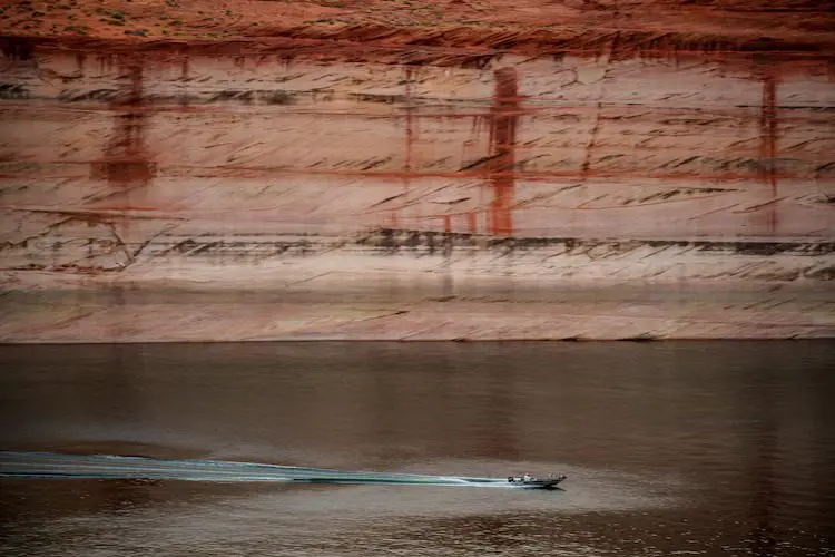
A cream-colored band lines the orange sandstone walls that rise above the blue-green waters of Lake Powell. The so-called “bathtub rings,” these chalky layers remind boaters zooming across the popular reservoir how far the lake has fallen.
After two decades of drought and an exceptionally warm winter, those rings will likely soon span even wider as Powell continues to drop towards a record low.
“Right now the hydrology that we have in front of us puts us in a very, very precarious situation,” said Gene Shawcroft, Utah’s Colorado River negotiator.
Utah just wrapped up its warmest winter on record. Salt Lake City broke its previous maximum average winter temperature by 2 degrees Fahrenheit — a significant increase, according to the Colorado Basin River Forecast Center. While the state received similar precipitation compared to last year, much of that fell as rain, leading to the worst snowpack since 1981 in parts of the state. Now, the water supply outlook is “well below normal,” according to the center.
The Bureau of Reclamation’s latest most probable forecast for Lake Powell shows it sinking below “power pool” — 3,490 feet — by December. At that level, water can’t make it through the turbines at Glen Canyon Dam that generate hydropower and keep the lights on across Utah and six other states.
Powell could hit that dangerous low even sooner, though. The bureau’s most recent forecast was based on the Colorado Basin River Forecast Center’s February report. Since then, the center’s projection for water flows into Powell has dropped by 100,000 acre-feet.
The bureau’s most probable forecast can also be optimistic. The agency’s minimum probable forecast, which shows a dry scenario that would statistically happen only 10% of the time, sometimes aligns more with reality. Last year, the April 2025 minimum probable study forecasted Lake Powell to hit 3,535 feet in elevation by the end of February 2026. The lake currently sits at 3,530 feet.
The bureau’s latest minimum probable forecast shows the lake dropping below 3,490 by the end of August.
“It’s safe for us to assume that, unless Mother Nature is uncharacteristically generous, that Lake Powell elevations are going to fluctuate at elevations that we’re not comfortable with,” Wayne Pullan, Upper Colorado regional director for the bureau, said at a Glen Canyon Dam meeting last week.
How the feds could boost Powell
To prop up Powell, the bureau will likely rely on another popular Utah reservoir: Flaming Gorge.
The reservoir that straddles the border of Utah and Wyoming has the best water outlook in the basin, at 64% of normal, according to the forecast center. The Upper Green River, which flows into Flaming Gorge, is the “lone bright spot” for snow water equivalent — the amount of water snow holds. Colder snow holds more water.
Under a 2019 plan, the bureau may form an agreement with Utah and the other states in the Upper Colorado River Basin — Colorado, New Mexico and Wyoming — to release water from Flaming Gorge and a few other reservoirs, such as Blue Mesa in Colorado, to maintain hydropower at Glen Canyon Dam.
That’s what happened the last time forecasts showed Powell dropping to a dangerous low level in 2022. A record wet winter followed that dry year, though, boosting the reservoirs.
That’s not something states can depend on every year in the future.
“Flaming Gorge is a finite resource,” Amy Haas, director of the Colorado River Authority of Utah, told The Tribune. “You may get two or three or four major releases out of Flaming Gorge before you’ve brought that reservoir down to the mud, so to speak.”
“It is not going to save the system,” she added.
In the short term, it may be Powell’s only hope, though.
Utah and the three other states in the Upper Colorado River Basin — Colorado, New Mexico and Wyoming — sent a letter to the bureau two weeks ago inviting them to form a plan for releases from Flaming Gorge and other upper reservoirs, Shawcroft said.
Releases would likely start on May 1 and go until April 30 of next year, Shawcroft added. The total water released could be around 500,000 acre-feet.
The bureau is also considering reducing how much it lets out of Powell to flow downstream to Lake Mead and ultimately Arizona, California and Nevada. The bureau has already held back nearly 600,000 acre-feet of water in Powell that it would normally release over the winter months.
Originally it planned to release that water this summer. That may not happen, though, depending on what adjustments the bureau ultimately has to make to prop up Powell, Pullan said during a meeting of the Colorado River Authority of Utah earlier this year.
“This summer might be a glimpse into what our future world is going to be, and that’s going to be really limited water use,” Jack Schmidt, director of the Center for Colorado River Studies at Utah State University, said.
“So many things are compromised now,” he added. “The only silver lining is that crises often force real innovation, and maybe that’s the only outcome that we get out of this.”
This article is published through the Colorado River Collaborative, a solutions journalism initiative supported by the Janet Quinney Lawson Institute for Land, Water, and Air at Utah State University. See all of our stories about how Utahns are impacted by the Colorado River at greatsaltlakenews.org/coloradoriver.